What is Traversing Surveying? (Traverse Definition)
The word traverse means ‘passing across.’ In surveying, it means ‘determining the lengths and directions of consecutive lines.’
The linear measurements are made with tape or chain, and the relative directions of the lines are measured with a compass, theodolite or Chain.
Direction provides and measurement of distance the essential two-dimensional data for determining the land area and for delivering horizontal control, i.e., the relative location of points in the horizontal plane.
The results of a level network for the same location, when added to this information, provides a three-dimensional representation of a section of the earth’s surface.
Traversing consists of reconnaissance (selecting. marking and referencing stations), picking up details, and booking the field notes.
A traverse, in general, is run to locate the features already existing in the area to be surveyed or to establish points or lines by predetermined measurements. Traverses are classified as either open or closed.
Type of Traversing Surveying.

- Open Traverse Surveying.
- Close Traverse Surveying.
#1. Open Traverse Surveying-

An open traverse is one that does not return to the starting point. It consists of a series of lines expanding in the same direction (Drawing No.1). As a matter of fact, an open traverse cannot be checked and adjusted accurately.
It is employed for surveying long narrow strips of country, e.g., the path of a highway, railway, canal, pipeline, coastline, transmission line, etc.
#2. Closed Traverse Surveying-

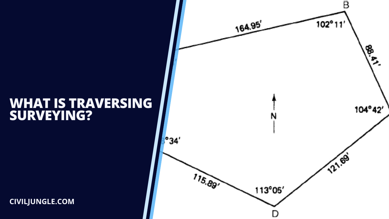
A traverse is said to be a closed one if it returns to the starting point, thereby forming a closed polygon (as per below polygon drawing)
Also, a traverse which ends and begins at positions on the plan is known are also referred to as a closed traverse (as per below trapezoidal drawing)
A closed traverse is employed for locating the boundaries of lakes and woods across which tie lines cannot be measured, for area determination, control for mapping. And for surveying moderately large areas.
Closed Traverse Survey Method
There are two types of traverse surveying. They are Closed traverse: When the lines form a circuit which ends at the starting point, it is known as a closed traverse. Open traverse: When the lines form a circuit ends elsewhere except starting point, it is said to be an open traverse.
[/su_box]Methods of Traverse Surveying.
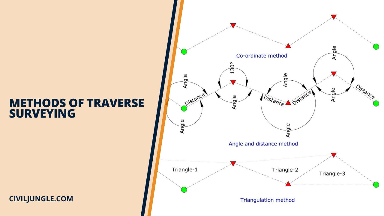
The linear measurements can be performed by any of the methods listed in the horizontal method. For ordinary surveying, chaining is perhaps the most common.
The direction of the lines can be measured by the techniques discussed in Compass surveying and Theodolite. The precision usually specified for traversing requires the use of steel tape and the theodolite.
However, any other combination of linear and angular measuring equipment may be used. The different methods of traversing are mentioned below.
Traverse Survey May Be Conducted as Below Method
- Chain traversing (by chain angle)
- Compass traversing (by free needle)
- Theodolite traversing (by fast needle)
- Plane table traversing (by plane table)
#1. Chain Traversing (by chain angle)-

In this method. The whole of the work is done with the chain and tape. No angle measuring instrument is used, and the directions of the lines are fixed entirely by liner measurements. Angles fixed by tie measurements or linear are known as chain angles. as per below finger
Shows a closed chain traverse.
At A, the directions AB and AD are fixed by internal measurements Aa1, Ad1, and a1d1 However. the direction may also be adjusted by external measures such as at station B (as per below drawing No.a, as per below drawing No.b)
Shows an open-chain traverse.
The method is unsuitable for actual work and is generally not used if an angle measuring instruments such as a sextant, compass, or theodolite is available.
#2. Compass Traversing (By Free Needle)-
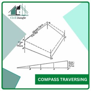
Compass and chain traversing, the magnetic bearings of the lines of the survey are t the length of lines is measured either with tape or with a chain and measured by a compass.
The direction of a magnetic meridian is established at each traverse station independently. The method is also known as free or lose needle method.
A theodolite fitted with a compass may also be used for measuring the magnetic bearings of the traverse line
However, the method is not so accurate as of that of transit tape traversing. The methods of taking the details are almost the same as for chain surveying.
Traversing is that types of the survey in which several connected survey lines form the directions, and the framework and lengths of the survey line are measured with the help of an angle (or direction) measuring instrument and tape (or chain) respectively.
It is known as a closed traverse When the lines form a circuit which ends at the starting point. If the circuit ends elsewhere, it is said to be an open traverse.
The various methods of traversing have been dealt with in detail in units of Angle Measurement. An angle is a difference in directions of two intersecting lines.
There are three popular systems of angular measurement.
| (a) Sexagesimal System : | 1 circumference | = 360°(degrees of arc) |
|---|---|---|
| 1 degree | = 60′(minutes of arc) | |
| 1 minute | = 60″ (second of arc) | |
| (b) Centesimal System : | 1 circumference | = 400s (grads) |
| 1 grad | = 100′ (centigrads) | |
| 1 centigrade | =100″(centicentigrads) | |
| (c) Hours System : | 1 circumference | = 24h (hours of time) |
| 1 hour | = 60m (minutes of time) | |
| 1 minute | = 60s (seconds of time) |
#3. Theodolite Traversing (By Fast Needle)-

In theodolite traversing, the directions are measured in the form of bearings, deflection angle, angle to the right, interior angles or azimuths using a theodolite and distance with a tape, electric distance measurement (EDM) equipment or by a tachometer.
Bearings are measured by theodolite fitted with a compass by loose needle method or fast needle method.
If the angles measured by deflection angles method, angle to the right, traverse they are called deflection angle traverse. It is specially used in an urban survey where triangulation is not possible.
The theodolite is an intricate instrument used mainly for accurate measurement of horizontal and vertical angles up to 10″ or 20″, depending upon the least count of the instrument. Uses, the theodolite is sometimes known as a universal instrument.
The following are the different purposes for which the theodolite can be used:
- Measuring horizontal angles
- Measuring vertical angles
- Measuring deflection angles
- Measuring magnetic bearings
- Measuring the horizontal distance between two points
- Finding the vertical height of an object
- Finding the difference of elevation between various type of points
- Ranging a line
Theodolites Traversing Surveying may be of two types
- Transit theodolite
- Non-transit.
In the transit theodolite, the telescope can be revolved through a complete revolution about its horizontal axis in a vertical plane. In the non-transit theodolite, the telescope cannot be rotated through a complete revolution in the vertical plane.
But it can be rotated to a certain extent in the vertical plane, to measure the angle of elevation or depression.
Theodolites may also be classified as
-
- Vernier theodolites—when fitted with a vernier scale
- Micrometer theodolites—when equipped with a micrometer.
The size of the theodolite is defined according to the diameter of the central horizontal graduated circle. For example, in a “10 cm theodolite”, the width of the central graduated ring is 10 cm. In an engineering survey, 8 cm to 12 cm theodolites is generally used.
#4. Plan Table Traversing (By Fast Needle)-

The plane table is one of the oldest surveying instruments. The distinguishing feature of plane table surveying is that field observations and plotting proceed simultaneously.
It is very well suited for the survey of detail in the vicinity of theodolite stations and is extensively used to record topographic details in engineering surveys.
Thus it is a graphical method of a survey in which the features being plotted are in full view of the surveyor. This is an advantage in many types of surveys in civil engineering, mining engineering, geology, and other disciplines.
Photogrammetry is now the principal method for the small-scale flapping of large areas. However, plane table surveying or ‘plane tabling’ is used as a supplemental method because it is simple and inexpensive.
Traversing of Plane Table Survey
Instead of a compass or theodolite, a plane table can be used to conduct a traverse survey. The detail is plotted by offsets as usual.
The traverse may be closed, as shown in Figure or open. The detail can also be fixed by radiation or intersection, depending on convenience in the field.
Orienting is done by backsighting on the previous station before sight is taken to the forward station. The error of closure is determined at a penultimate station without occupying the last station. Intermediate checks are done wherever possible.
Thus, if A is visible from C, D is sighted with the alidade against c and its edge touching a. Plane table traversing becomes analogous to a compass traverse if the orientation is entirely by compass.
Although not as accurate as an orientation by backsighting, the method is useful for long, open traverses with relatively short sides since compass errors tend to compensate.
A small, light form of a plane table with a trough compass recessed into the board is used for such work. It is called a traverse plane table or simply a traverse table.
Procedure of Traverse
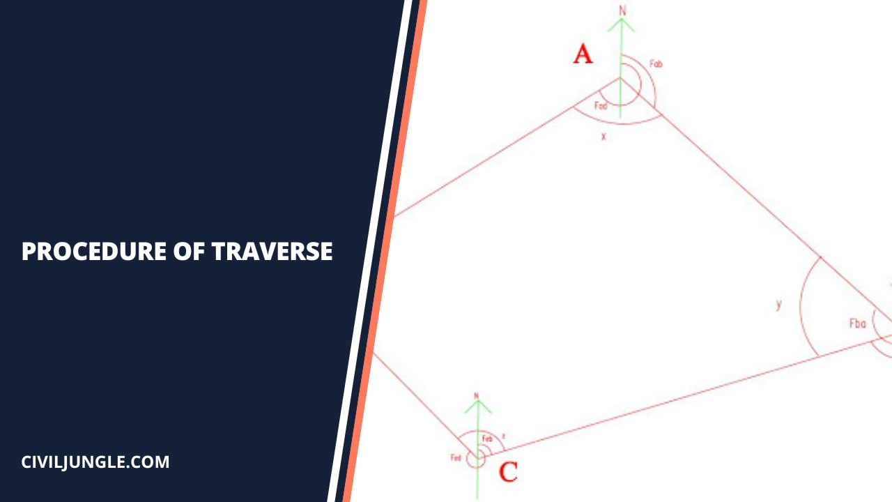
The following steps required to establish a traverse.
Reconnaissance

Reconnaissance is the preliminary field inspection of the entire area to be surveyed. During reconnaissance. Surveyor goes to the field, checks the entire area, and decides the best plan of working.
He has to see the suitability and intervisibility of traverse stations. Also, he has to decide which method of traversing will be employed and accordingly, the instruments and accessories that may be necessary.
Selection of Traverse Stations
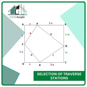
The basic principle of a survey, i.e., working from whole to the part should be adopted. A minimum number of stations should be selected.
Length of traverse lines is as long as possible reduce time and centering effect of the stations. It is better to select stations on a level and firm ground. After the selection of stations, they are marked with pegs.
Linear and Angular Measurements

Distances between stations are measured by tape or chain, or tacheometric method or electric distance measurings (EDM) instruments like geodimeter or distameter. Angular measurements are done by prismatic compass or theodolite.
Plotting of Tranverse Survey

There are two methods of plotting a traverse survey. The methods are as follows
Distance and Angle Method In This Method

distances between stations are laid off to scale and included angles or bearings are plotted by protector or tangent of angle or chord of the angle.
Co-Ordinate Method

In this method, survey stations are plotted by calculating their co-ordinates. This method is more practical and accurate. The biggest advantage of this method of plotting is that closing error can be eliminated by balancing.
Closing Error and Adjustments

When a close traverse is plotted according to field measurements, the ends of the traverse usually do not coincide owing to the error in the measurement of angles and distances.
Errors in angles mostly occur due to local attraction. This error is called the closing error. As per below Figure (a), AA’ is closing error, i.e. AA’ = e
Adjustment of Closing Error by Graphic Method

In as per above Figure (a), the polygon, ABCDEA’ represents an unbalanced traverse having closing error equal to e, AA’ = e as the point A and last point A’ are not coinciding.
The closing error AA’ (e) is distributed linearly to all sides in proportion to their length by graphical construction shown in as per above Figure (b) in which AB’, B’C, CD’, LYE’, E’A’ are the lengths of the sides of traverse AB, BC, CD, DE, and EA either to the same scale as per above Figure Figure (a) or in reduced scale.
The ordinate A’a is equal to the closing error AA’ of Figure (a). Join Aa and drop perpendiculars (or parallel lines of A’a) E’e, Lid, Cc, B’b on line AA’ as shown in as per above Figure Figure (b).
Thus similar triangles are formed and corresponding error E’e, D’d, Cc, B’b are obtained. as per above Figure (c). EE’, DD’, CC and BB’ are drawn a parallel of closing error AA’.
Then cut EE’ = E’e, DD’ = D’d, CC = Cc and BB’ = B’b. Join AE, ED, DC, CB, and BA. The polygon ABCDE so obtained in as per above Figure Figure (c) represents the adjusted traverse.
Bowditch’s Method.
The basis of this method is on the assumption that the errors in linear measurements are proportional to f and that the errors in angular measurements are inversely proportional to √l where l is the length of a line. Bowditch’s rule.
Also termed as the compass rule, is mostly used to balance a traverse where linear and angular measurements are of equal precision. The total error in latitude, and in the departure is distributed in proportion to the lengths of the sides.
The Bowditch Rule is :
Correction to latitude (or departure) of any side =Total error in latitude (or departure) x (Length of that thee / Perimeter of traverse)
Thus, if Ce = correction to the latitude of any side
CD = correction to the departure of any side
EL = total error in latitude
D = total error in departure
El = length of the perimeter
I = length of any side
CI =∑L.(l/∑l) and
Cd = ∑D .(l/∑l)
Transit Method
The transit rule may be employed where angular measurements are more precise that the linear measurements.
According to this rule, the total error in latitudes and in departures is distributed in proportion to the latitudes and departures of the sides.
It is claimed that the angles are less affected by corrections applied by the transit method than by those by Bowditch’s method.

Advantages and Disadvantages of Methods of Plotting Traverses

The various methods of plotting a traverse have their own advantages and disadvantages.
- Plotting a traverse by the method of included angles or directions with a protractor is the least accurate but the fastest method.
- The most accurate and the best method to layout a single angle precisely is by tangents.
- If a traverse fails to close and if the error is due to drafting, the error may be adjusted simply by rotating each line, except the first, slightly and progressively.
- In the chord method of plotting a traverse, the erection of a perpendicular (in the tangent method) is eliminated, but the determination of the chord length is more laborious than finding perpendicular offsets.
- The main disadvantage of the chord method is that an error in any of the traverse line is passed through along to the succeeding line.
- Plotting by independent coordinates is supposed to be a better method since the independent coordinates of the stations do not affect the succeeding coordinates and thus the error, if any, is localized to a particular point and therefore, correction usually involves the replotting of the erroneous point only.
- In plotting with consecutive coordinates, small errors of plotting are carried forward, and in a closed traverse, the closing error due to inexact plotting can be located since the coordinates used have already been balanced.
- This may be considered to be an advantage, as the cause of discrepancy can be searched for and eliminated.
- Since errors are not accumulated when plotting with independent coordinates, they are preferred for plotting an open traverse
Traversing in Surveying
Frequently Asked Questions about Traversing in Surveying
What is traversing in surveying?
Traversing in surveying refers to the process of determining the lengths and directions of consecutive lines. This technique involves linear measurements made with tape or chain and relative direction measurements made with a compass, theodolite, or chain.
What are the types of traversing surveys?
There are two main types of traversing surveys:
- Open Traverse Surveying: A series of lines that do not return to the starting point, commonly used for surveying long, narrow strips such as highways or pipelines.
- Closed Traverse Surveying: A series of lines that form a closed polygon, returning to the starting point, used for defining boundaries and areas.
What are the methods of linear measurement in traversing?
Linear measurements in traversing can be performed using various methods, such as chaining, which is the most common for ordinary surveying.
How are directions measured in traversing?
Directions of the lines in traversing can be measured using techniques discussed in compass surveying and theodolite surveying, with precision typically requiring a steel tape and a theodolite.
What is chain traversing?
Chain traversing is a method where all work is done with chain and tape, fixing the directions of lines entirely by linear measurements without using angle measuring instruments. This method is generally unsuitable for accurate work if other instruments are available.
What is compass traversing?
Compass traversing involves measuring the magnetic bearings of survey lines with a compass and measuring line lengths with a tape or chain. This method is known as the free needle method and is less accurate than transit tape traversing.
What is theodolite traversing?
Theodolite traversing involves measuring directions using a theodolite and distances with tape, EDM equipment, or a tachometer. This method allows for accurate measurement of horizontal and vertical angles.
What is plane table traversing?
Plane table traversing involves using a plane table to conduct a traverse survey with field observations and plotting done simultaneously. It is suitable for surveying details near theodolite stations and recording topographic details.
What are the steps involved in establishing a traverse?
Establishing a traverse involves reconnaissance (field inspection), selection of traverse stations, linear and angular measurements, plotting the traverse survey, and addressing closing errors and adjustments.
What is a closing error in a traverse survey, and how is it adjusted?
A closing error occurs when the ends of a traverse do not coincide due to measurement errors. This error can be adjusted using methods like the Bowditch’s method or the transit method, distributing the error proportionally to the lengths or coordinates of the sides.
What are the advantages and disadvantages of different methods of plotting traverses?
Different plotting methods have their own pros and cons:
- Included angles or directions with a protractor: Fast but least accurate.
- Tangent method: Precise but labor-intensive.
- Chord method: Eliminates perpendicular erection but more laborious in determining chord length.
- Independent coordinates: Localize errors but involve replotting if errors occur.
- Consecutive coordinates: Carry forward small errors but help identify and correct discrepancies.
When is the Bowditch’s method used for adjusting closing errors?
Bowditch’s method, also known as the compass rule, is used when linear and angular measurements are of equal precision. It distributes the total error in latitude and departure proportionally to the lengths of the traverse sides.
What is the transit method for error adjustment?
The transit method is used when angular measurements are more precise than linear measurements. It distributes the total error in latitudes and departures proportionally to the latitudes and departures of the sides.